


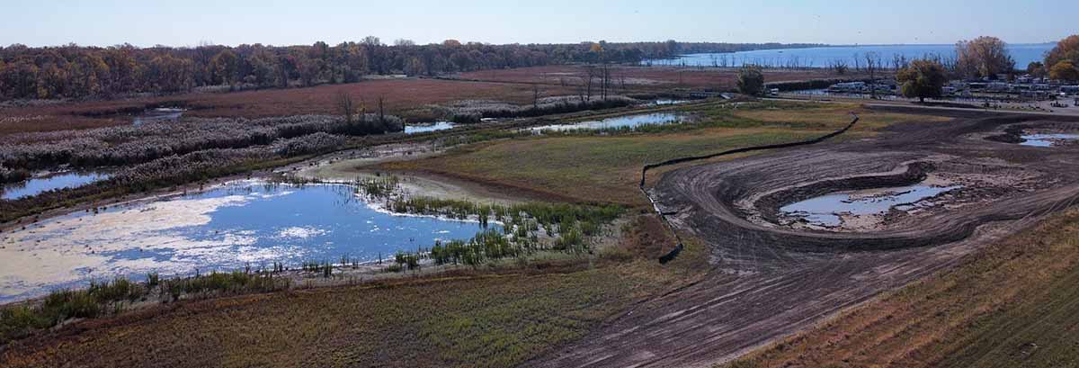
Rondeau Bay and the surrounding areas are independently identified as a Key Biodiversity Area (KBA) by the International Union for the Conservation of Nature (IUCN) and an Area of High Ecological Value by Environment and Climate Change Canada.12,13 These designations outline the significance of the area’s contribution to the global persistence of biodiversity and its importance for the life history of many rare and at-risk species.
Wetlands are areas that flood every season or have water permanently present.2 In the Great Lakes, wetlands include swamps, bogs, fens, and most commonly marshes. Provincially Significant Wetlands are wetland identified by the Province of Ontario as being the most ecologically valuable and as a result, received special protections.
Wetlands serve as water’s natural filter. They protect coastal areas from storms, flooding, and erosion, create habitat for many insects, birds, reptiles, mammals, and fishes, and provide beautiful areas for recreational activities.3
Despite their important functions, wetlands are becoming very rare. In the settled areas of Canada, 70% of wetlands have been destroyed or degraded. In the Kent region, 98.5% of wetlands were lost between pre-settlement (circa 1800) and 2022. Today, only 0.8% of the Kent region remains as wetland habitat.4
Restoration of the Keith McLean Conservation Lands
Pre-settlement, much of the Rondeau Bay area, including the Keith McLean Conservation Lands, was a vast coastal wetland. In the 1950’s, the existing wetland was pumped and drained for agricultural purposes. In 2022, a 2.5-hectare (6-acre) restoration project was completed to help re-establish the historic coastal wetland. This project complements previous work conducted in 2007, which restored 27 hectares (67 acres) of wetland on the southern boundary of the property along Rose Beach Line and towards Rondeau Bay. In combination, these projects form the largest continuous coastal wetland in the Greater Rondeau Area outside of Rondeau Provincial Park. Coastal wetlands are important ecosystems that aid in flood storage, and water filtration, and provide habitat for a variety of species.
What Species Can You Find at the Keith McLean Conservation Lands?
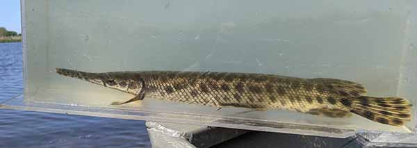 Spotted Gar were listed as Endangered under the Species at Risk Act in 2016 because the wetlands they rely on were completely destroyed or degraded by the removal of aquatic vegetation and high inputs of sediment and nutrients, leading to turbid water conditions.6 Rondeau Bay and the surrounding area is one of only three coastal wetland complexes in Canada where the Spotted Gar is still found. To reproduce, Spotted Gar require low flow, shallow, and highly vegetated water with underwater structures such as fallen tree branches.5 All Gar species have bony armour-like scales and a large, elongated jaw with needle-like teeth, however, compared to other Gar species (e.g., Longnose Gar), Spotted Gar have a shorter and stubbier alligator-like snout.1,8 (PC: Craig Paterson)
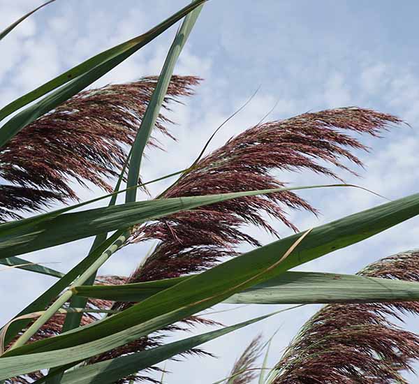 European Common Reed (Phragmites australis) is an invasive plant that can grow up to 6 metres (20 feet) tall. Phragmites grow in dense mats, making wetland habitats inaccessible to many species.7 (PC: Nicole Drumm)
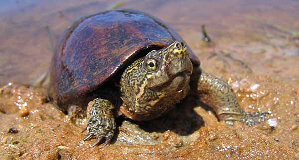 Eastern Musk or Stinkpot Turtles (Sternotherus odoratus) get their name from the musky odour they release when they are frightened or threatened. Unlike other turtles, they are not strong swimmers and are often seen walking along the bottom of wetlands.11 (PC: Scott Gillingwater)
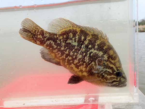 The Warmouth (Lepomis gulosus), a species of Special Concern, is a member of the sunfish family and shares a similar distribution to the Spotted Gar – they have also only been found in three Lake Erie coastal wetlands. Warmouth can be distinguished from other sunfishes in the Lepomis family by their large mouth and small patch of teeth on their tongue.9 (PC: Dominique Rumball)
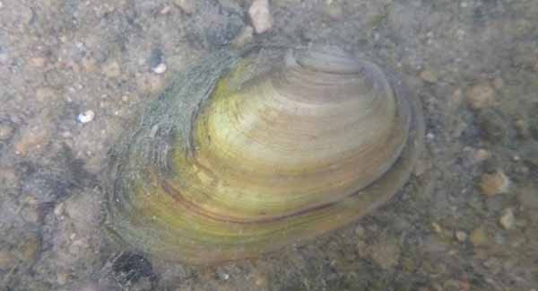 Giant Floater Mussels (Pyganodon grandis) are one of the most widespread mussel species in Ontario. They are often the first mussels to establish in new wetlands as they can survive in a variety of different habitats and can travel by floating on top of water.10
- Holm, E., N.E. Mandrak, and M. Burridge. 2021. A Field Guide To Freshwater Fishes of Ontario. Second Edition. Royal Ontario Museum Publishing, Toronto, Canada.
- Canadian Wildlife Service of Environment Canada. 2002. Great Lakes Coastal Wetlands– Science and Conservation. Accessed July 17, 2023, from https://publications.gc.ca/collections/Collection/En40-222-11-2002E.pdf.
- Steinman, A., B. Cardinale, W. Munns, M. Ogdahl, J. Allan, T. Angadi, S. Bartlett, K. Brauman, M. Byappanahalli, and M. Doss. 2017. Ecosystem services in the Great Lakes. Journal of Great Lakes Research 43: 161-168.
- Ducks Unlimited Canada. 2010. Southern Ontario wetland conversion analysis: final report. Ducks Unlimited. Barrie, Ontario. 23 pp.
- Fisheries and Oceans Canada. 2021. Recovery Strategy and Action Plan for the Spotted Gar (Lepisosteus oculatus) in Canada [Proposed]. Species at Risk Act Recovery Strategy Series. Fisheries and Oceans Canada, Ottawa. iv + 71 pp.
- Species at Risk Act, SC 2002, c 29, <https://canlii.ca/t/55cfs> retrieved on July 15, 2023.
- Ontario Federation of Anglers and Hunters and Ministry of Natural Resources and Forestry. 2023. Invasive Phragmites. Ontario’s Invading Species Awareness Program. Retrieved July 21, 2023, from https://www.invadingspecies.com/invaders/plants/invasive-phragmites-2/.
- Scott W., and Crossman, E. 1973. Freshwater Fishes of Canada, Second Edition. Bulletin 184, Fisheries Research Board of Canada, Ottawa, pp 721-722.
- COSEWIC. 2015. COSEWIC assessment and status report on the Warmouth Lepomis gulosus in Canada. Committee on the Status of Endangered Wildlife in Canada. Ottawa. x + 47 pp. (www.registrelep- sararegistry.gc.ca/default_e.cfm).
- Government of Ontario. 2021. Species at risk. ca Retrieved July 19, 2023, from https://www.ontario.ca/page/species-risk.
- Reid, S.M., Kopf, V., Morris, T.J. 2018. Diversity of freshwater mussel assemblages across Lake Ontario coastal wetlands in Canadian waters. Can. Manuscr. Rep. Fish. Aquat. Sci. 3164: v + 21 p.
- Key Biodiversity Areas. 2023. Accessed October 4, 2023 from: https://www.keybiodiversityareas.org/kba-data.
- Environment and Climate Change Canada. 2022. Development and Implementation of an Approach for Identifying Areas of High Ecological Value in Canadian Great Lakes Nearshore Waters. Accessed October 4, 2023 from: https://data-donnees.ec.gc.ca/GreatLakesNearshoreWaters_HighEcologicalValue.pdf.
News & Blog
 St. Clair Region Conservation Authority Celebrates 2026 Conservation Scholarship RecipientsJuly 21, 2026
 TTLT and SCRCF Host Recognition Event at Bradshaw Conservation LandsJune 2, 2026
 Scholarships Available through the St. Clair Region Conservation AuthorityMay 1, 2026
 SCRCA Hosts A.W. Campbell Maple Syrup Festival March 21 – Alvinston Firefighters Association to Hold Pancake Breakfast March 21 and 22March 9, 2026
 St. Clair Region Conservation Authority Celebrates a Year of Environmental Progress at 2026 Annual General MeetingFebruary 27, 2026