


Lake St. Clair is the smallest lake in the Great Lakes system. Together with the St. Clair and Detroit Rivers, it forms the connecting channel between Lakes Huron and Erie, and is divided by the international boundary between Canada and the United States. The majority of the lake and its watershed are in Ontario.
Lake St. Clair is an integral link in the major shipping corridor that connects Great Lakes ports with international destinations. The delta at the lake’s north end is the largest freshwater delta in the world and one of the most significant fish and wildlife habitats in the Great Lakes. The Canadian portion of the watershed is predominantly agricultural, and includes one of the most productive agricultural areas in Canada. The U.S. portion of the watershed is highly urbanized, and includes portions of the city of Detroit and Greater Detroit Area.
What is the Lake St. Clair Canadian Watershed Management Plan?
The Canadian Watershed Management Plan provides a framework to encourage cooperation and collaboration. It is the link between local tributary watershed programs and Great Lakes basin-wide initiatives.
The Plan:
- Identifies management issues, and sets goals to address them;
- Recommends actions to address issues affecting the Canadian portion of the Lake St. Clair ecosystem;
- Provides a common vision, principles and goals for the lake; and
- Includes input from Lake St. Clair partners and the public.
The Plan’s authors, the Lake St. Clair Canadian Watershed Coordination Council, recognize that communication and partnerships with U.S. counterparts are vital to ensuring that the Lake St. Clair ecosystem is effectively managed.
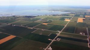
Land use is the single largest stressor to the Lake St. Clair ecosystem. Effective land use management will result in the greatest improvement to conditions in the lake. Agricultural and urban land uses increase the amount of sediment and nutrients entering the lake. Credit: St. Clair Region Conservation Authority.
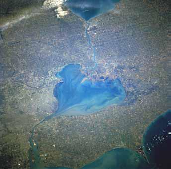
When viewed from space, Lake St. Clair is easily identified as the “heart” of the Great Lakes. Also visible in this photograph: Lake Huron and the St. Clair River are above the lake, to the north; and the Detroit River and Lake Erie are below the lake, to the south. The Canadian watershed is on the right of the image, and the U.S. watershed is on the left. Credit: Image Science What are the Issues in the Canadian Lake St. Clair Watershedand Analysis Laboratory, NASA-Johnson Space Center. “The Gateway to Astronaut Photography of Earth”.
What are the Issues in the Canadian Lake St. Clair Watershed?
In 2005, Canadian lake managers completed a comprehensive technical review and identified three priority issues in the Canadian Lake St. Clair watershed: land use, commercial and recreational boating, and loss of habitat and biodiversity. Land use is the single largest stressor to the Lake St. Clair ecosystem. Effective land use management will result in the greatest improvement to the Lake St. Clair ecosystem.
Other areas where targeted actions are needed include: reducing sources of pollution; reducing risks to human health; encouraging sustainable fishing and hunting; and improving governance, monitoring, scientific studies and data management.
Why was a Canadian Plan Developed?
Under the Great Lakes Water Quality Agreement, the governments of Canada and the United States have agreed to work together to address binational issues in the Great Lakes basin, including Lake St. Clair. The federal governments have a Four Agency Agreement with the province of Ontario and the state of Michigan to coordinate issues and activities related to Lake St. Clair.
The conditions on the U.S. and Canadian sides of Lake St. Clair are very different, as are the environmental problems and their causes. For this reason, two distinct management plans were developed for Canada and the U.S. to target the specific challenges within each jurisdiction.
How is the Canadian Plan Implemented?
The members of the Lake St. Clair Canadian Watershed Coordination Council are working in collaboration with other partners to implement the management recommendations. The Canadian Watershed Coordination Council is:
- Maintaining the Lake St. Clair Canadian Work Plan, which is a framework for the implementation of actions. The Work Plan addresses scientific research, monitoring and reporting, and will be reviewed and updated annually.
- Integrating its activities in an ongoing partnership with the Lake Erie Lakewide Action and Management Plan (LAMP).
- Reporting on progress through the biennial Lake St. Clair conference held in collaboration with the United States.
- Encouraging consistent programming and sustainable funding to support beneficial management programs over the long-term.
- Continuing to work with U.S. partners to ensure a coordinated binational focus on Lake St. Clair watershed management issues.
The Canadian Watershed Coordination Council is made up of federal, provincial and First Nations governments and local conservation authorities. Their role is to coordinate activities in the Canadian Lake St. Clair basin so that efforts and resources are focused more efficiently and effectively.
The Coordination Council is made up of:
- Environment and Climate Change Canada
- Walpole Island First Nation
- Ontario Ministry of the Environment and Climate Change
- Ontario Ministry of Natural Resources and Forestry
- Ontario Ministry of Agriculture, Food and Rural Affairs
- St. Clair Region Conservation Authority
- Essex Region Conservation Authority
- Lower Thames Valley Conservation Authority
- Upper Thames River Conservation Authority
How Can You Get Involved?
Cooperation from citizens, businesses, First Nations and all levels of government is vital to the success of the plan. Here are just a few ways to get involved:
- Implement agricultural, rural, industrial or urban beneficial management practices and programs to enhance water quality, water quantity and habitat sustainability;
- Promote and participate in sound land use management practices and habitat restoration and protection projects;
- Stop the spread of established invasive species and prevent future introductions of other invasive species;
- Promote clean drinking water and practice and promote water conservation measures;
- Promote and implement environmentally friendly boating practices, and;
- Reduce atmospheric emissions, reduce reliance on non-renewable energy sources like fossil fuels and adopt energy conservation measures.
Lake St. Clair Canadian Watershed Facts
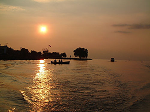
The Lake St. Clair Canadian watershed contains key habitats that are critical to maintaining populations of fish and wildlife, such as the egret (left). In turn, these habitats and populations support fishing, hunting and tourism opportunities in the region (above). Credits: Naomi C. Williams, Walpole Island Heritage Centre (left) and Ontario Ministry of Natural Resources, Lake Erie Management Unit (above).
Lake St. Clair
Surface Area: 1,114 km2 (694 km2 Canadian)
Shoreline Length: 272 km, excluding the delta
Mean Depth: 3.7 m
Natural Maximum Depth: 6.4 m
Shipping Channel Depth: 8.3 m
Canadian Watershed
Total Watershed Area: 13,500 km2
Canadian Watershed Area: 10,000 km2
Largest Canadian Subwatersheds:
Thames River 582,700 ha
Sydenham River 272,400 ha
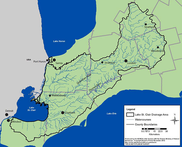
The Lake St. Clair Canadian Watershed (outlined in black), showing rivers and major population centres. Source: St. Clair Region Conservation Authority.
For more information email [email protected]
News & Blog
 St. Clair Region Conservation Authority Celebrates 2026 Conservation Scholarship RecipientsJuly 21, 2026
 TTLT and SCRCF Host Recognition Event at Bradshaw Conservation LandsJune 2, 2026
 Scholarships Available through the St. Clair Region Conservation AuthorityMay 1, 2026
 SCRCA Hosts A.W. Campbell Maple Syrup Festival March 21 – Alvinston Firefighters Association to Hold Pancake Breakfast March 21 and 22March 9, 2026
 St. Clair Region Conservation Authority Celebrates a Year of Environmental Progress at 2026 Annual General MeetingFebruary 27, 2026