


• About
    • Mission / Vision Statement
    • Governance / Board of Directors
    • Board Meeting Packages
    • Area of Jurisdiction
    • Publications/Forms
    • Events
    • Tender Documents
    • Employment Opportunities
    • Accessibility
    • News & Blog
    • SCRCA Staff Directory
    • Service Disruptions
    • Contact Us
  • Permits & Planning
    • Introduction
    • Property Inquiry
    • Map Your Property
    • Regulations Permits
    • Drainage Act Project Review
    • Plan Input and Review
    • Policies and Guidelines
    • Fee Schedule
  • Water Management
    • Flood Notices
    • Flood Notice Types
    • W. Darcy McKeough Floodway
    • Low Water Response
    • Riverbank & Shoreline Protection Development
    • Erosion Control Projects
    • Great Lakes and Connecting Channels
  • Watershed Services
    • Tree Planting / Woodlot Services
    • Environmental Monitoring
    • Habitat Restoration Projects
    • Grants for Landowners
    • Invasive Species
  • Conservation Lands
  • Education
  • Foundation
    • About the SCRCF
    • Donate to our Foundation
    • Planned Giving
    • Memorial Forests
    • Sponsors
    • Land Donations
    • Scholarships
    • Green Meetings
  • Contact Us
St. Clair Region Conservation AuthoritySt. Clair Region Conservation Authority
Flood Status NORMALLow Water Status Level 1
  • About
    • Mission / Vision Statement
    • Governance / Board of Directors
    • Board Meeting Packages
    • Area of Jurisdiction
    • Publications/Forms
    • Events
    • Tender Documents
    • Employment Opportunities
    • Accessibility
    • News & Blog
    • SCRCA Staff Directory
    • Service Disruptions
    • Contact Us
  • Permits & Planning
    • Introduction
    • Property Inquiry
    • Map Your Property
    • Regulations Permits
    • Drainage Act Project Review
    • Plan Input and Review
    • Policies and Guidelines
    • Fee Schedule
  • Water Management
    • Flood Notices
    • Flood Notice Types
    • W. Darcy McKeough Floodway
    • Low Water Response
    • Riverbank & Shoreline Protection Development
    • Erosion Control Projects
    • Great Lakes and Connecting Channels
  • Watershed Services
    • Tree Planting / Woodlot Services
    • Environmental Monitoring
    • Habitat Restoration Projects
    • Grants for Landowners
    • Invasive Species
  • Conservation Lands
  • Education
  • Foundation
    • About the SCRCF
    • Donate to our Foundation
    • Planned Giving
    • Memorial Forests
    • Sponsors
    • Land Donations
    • Scholarships
    • Green Meetings
  • Contact Us

W. Darcy McKeough Floodway

Home Water ManagementW. Darcy McKeough Floodway

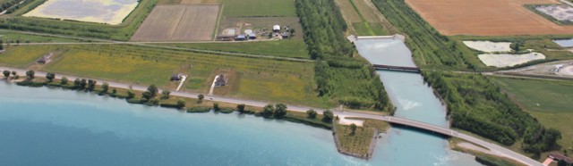
Mouth of the Darcy McKeough Floodway Channel

The W. Darcy McKeough Floodway is the largest flood diversion project in Ontario. The floodway was completed in 1984 to reduce the threat of flooding in the Town of Wallaceburg. The floodway is situated approximately twelve kilometres north of Wallaceburg in Sombra Township. It consists of an earth fill dam embankment and concrete control structure housing two vertical sluice gates. The grass lined diversion channel stretches seven kilometres west to the St. Clair River. Near the channel outlet, a concrete drop structure reduces the energy of the diverted flood waters before entering the St. Clair River. The drop structure also separates the St. Clair River from the normally dry channel.

The control gates remain open under normal flow conditions, but when Wallaceburg is threatened by flooding, they are closed and divert the flow down the diversion channel. The McKeough Floodway is capable of controlling all flood water upstream of the dam by diversion and temporary storage. The floodway is located such that it controls approximately 37% of the East and North Sydenham River drainage basins upstream of Wallaceburg.

Flood & erosion Links

  • Flood Notices
  • Flood Notice Types
  • W. Darcy McKeough Floodway
  • Riverbank & Shoreline Protection Development
  • Low Water Response
  • Erosion Control Projects
  • Great Lakes and Connecting Channels
  • Publications

Great Lakes Programs

  • Great Lakes and Connecting Channels
  • St. Clair River Area of Concern
  • Healthy Lake Huron
  • Phosphorus Reduction in the Great Lakes
  • Creating Soft Shorelines
  • Lake Huron Conservation Areas

About Us

The St. Clair Region Conservation Authority is located in southwestern Ontario and includes the Sydenham River watershed and smaller watersheds draining directly into southern Lake Huron, the St. Clair River, and northeastern Lake St. Clair.

The Conservation Authority implements programs to reduce the risk to life and property from flooding and erosion; water and land stewardship; forestry; wildlife habitat creation and outdoor recreation.

Partner Links

  • Conservation Ontario
  • Thames-Sydenham & Region Source Protection Area
  • Healthy Lake Huron
  • Sydenham River Website
  • Friends of the St. Clair River
  • Forest Gene Conservation Association
  • Lake St. Clair Canadian Watershed Management Plan
  • Ontario Trillium Foundation

Connect with us!

  • St. Clair Region Conservation Authority
  • 205 Mill Pond Cres., Strathroy ON N7G3P9
  • 519-245-3710
  • 519-245-3348
  • stclair@scrca.on.ca

© 2026 · St. Clair Region Conservation Authority

  • Home
  • Accessibility
  • Privacy
  • Director Access
  • Foundation Access
  • WM