Flood Watch – April 20, 2019 – Event 4, Bulletin 4
Highlights: Upwards of 30 mm of rain received in locations across the region as of this afternoon, with an additional...
Highlights: Upwards of 30 mm of rain received in locations across the region as of this afternoon, with an additional...

Highlights: Upwards of 35mm received over the course of the past week 50 – 55 mm of precipitation forecast over...
Highlights: 10 – 15 mm of precipitation forecast over the next 72 hours Heavy rain anticipated later in the week...

Highlights: 30 to 35 mm of precipitation forecast over the next 72 hours Water levels expected to rise Fast flowing...

Highlights: 15 – 25 mm of precipitation forecasted over the next 48 hours Water levels expected to rise Fast flowing...

Highlights: 10 – 20 mm of rainfall today 5 – 10 mm of precipitation and warm temperatures in the next...
Highlights: 10 – 20 mm of rainfall yesterday 10 – 15 mm of precipitation in the next 48 hours Water...

Highlights: 10 – 20 mm of rainfall yesterday Water levels gradually rising River ice continues to deteriorate Fast flowing water...

Highlights: 5-10 mm of precipitation across the watershed Fast flowing water and slippery banks Water levels to rise over next...
Highlights: 15 – 25 mm of precipitation Water levels gradually rising River ice continues to deteriorate Fast flowing water and...
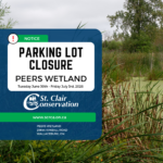 Notice of Temporary Parking Lot Closure at Peers Wetland Commencing on June 30th, 2026
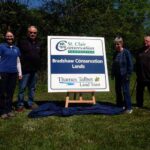 TTLT and SCRCF Host Recognition Event at Bradshaw Conservation Lands
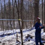 SCRCA Hosts A.W. Campbell Maple Syrup Festival March 21 – Alvinston Firefighters Association to Hold Pancake Breakfast March 21 and 22
 St. Clair Region Conservation Authority Celebrates a Year of Environmental Progress at 2026 Annual General Meeting
© 2026 · St. Clair Region Conservation Authority