


Frequently Asked Questions and Answers
To carry out an area specific coastal engineering assessment utilizing accepted engineering principles to determine the dynamic beach limit along 1.3 km of West Ipperwash beach (Centre Sideroad to West Ipperwash Road). Assess existing protection, input to existing development guidelines and provide best management practices.
The criteria for the dynamic beach as stated in the Technical Guide (MNR, 2001- p.5-10) is as follows:
– Beach or dune deposit exists landward of the water line; and
– Beach or dune deposit overlying bedrock or cohesive material is equal to or greater than 0.3m in thickness, 10m in width, 100m in length; and
– The max fetch measured over a 60 deg arc on either side of a line perpendicular to the shoreline is greater than 5m (i.e. not an enclosed bay).
West Ipperwash Beach meets the criteria for a dynamic beach.
Yes, the SCRCA Regulates the dynamic beach hazard limit plus 15 metres. SCRCA regulates these lands to ensure that development does not aggravate existing erosion, flooding or dynamic beach hazards or create new hazards. Conservation Authorities ensure new development is not at risk from hazards.
Jurisdiction note
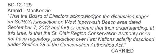
The Supreme Court of Canada determined that CKSP First Nations have use of the foreshore beach, but that lot parcels are privately owned. Parties work together to clean and groom the beach. The following is a motion passed by the St Clair Region Conservation Authority Board in 2012.
Average level for period of record = 176.42 m
Average level for July 2016 = 176.84 m
6 month forecast = 176.78 – 176.84 m (8/16)
(Source www.glerl.noaa.gov; acquired August 25, 2016)
Goderich station = 2016/08/25; 176.875
6 month Forecast – Maintain or slight decline
Lake levels vary daily, seasonally and annually.
Further information is provided in the SCRCA’s Lambton Shores Tributaries Watershed Report Card, 2011, which is available online at http://www.lakehuroncommunityaction.ca/wp-content/uploads/2016/03/Lambton-Shores-Watershed-Report-2011.pdf.
This is what the SCRCA knows: Kettle Point acts as a giant hook, collecting debris that would normally be carried along by Lake Huron flow. “Theories on the black muck’s origins range from decaying woody material trapped in the basin created by Kettle Point, to inland organic material carried to the lake during heavy rainfall events, to bacteria growing in detritus naturally found in the lake. Thus far, the black muck seems to have no ill effects on health and remains largely an unpleasant aesthetic concern. If, however, the black muck contains a high proportion of algae, then similar bacterial contamination concerns would exist should the muck decay in the strand line” (LHCC 2011). A black muck sample was taken during beach monitoring on August 17, 2011. The sample was observed under 20x magnification by SCRCA staff. It was found to contain 44% sand, 25% wood/woodchips, 18% algae filaments, 10% macrophytes, 3% Iridescent material.
BMP’s will be recommended by the coastal consultant. Implementation to be determined.
There is a discussion paper authored by Dr. Robin Davidson-Arnott available at the ABCA website under the following link: http://www.abca.on.ca/downloadfile.php?Item=483
Below is an excerpt:
3.5 Aeolian sand transport and coastal dune formation and stability
Greater exposure to intense storms may also lead to more frequent dune erosion and rebuilding cycles, leading to shorter times for foredune recovery and the potential for more sand to be transported onto the crest and lee slopes of the foredune. However, the impact of this disturbance should be contained within the primary foredune zone and have little impact on the area landward.
Conclusions
4) The duration and extent of ice cover in southern Lake Huron had already decreased and is predicted to decrease further by the end of the century. The most important impact of this longer ice-free season on coastal processes will be an increase in the number of storms associated with large waves and large storm surges. This effect is enhanced by the fact that storms during the winter months are generally more frequent and more intensive than spring and summer. In turn, the greater frequency of storms and increased number of intense storms will drive larger volumes of longshore sediment transport and an increase in the rate of downcutting of the nearshore and erosion of the bluff toe along cohesive shorelines. There may be some changes in the vegetation along sandy beaches and the potential for some increase in sand transport from the beach to the foredune and the frequency of events leading to erosion of the foredune.
5) The potential for enhanced rates of longshore sediment transport and bluff erosion as well as impacts on the dynamics of sandy beach and dune systems can be addressed within the general framework of the shoreline management plan and the Provincial Policy. However, it will require increased vigilance to ensure that the average annual recession rates are updated regularly as new aerial photography, and possibly LiDAR, become available
News & Blog
 St. Clair Region Conservation Authority Celebrates 2026 Conservation Scholarship RecipientsJuly 21, 2026
 TTLT and SCRCF Host Recognition Event at Bradshaw Conservation LandsJune 2, 2026
 Scholarships Available through the St. Clair Region Conservation AuthorityMay 1, 2026
 SCRCA Hosts A.W. Campbell Maple Syrup Festival March 21 – Alvinston Firefighters Association to Hold Pancake Breakfast March 21 and 22March 9, 2026
 St. Clair Region Conservation Authority Celebrates a Year of Environmental Progress at 2026 Annual General MeetingFebruary 27, 2026