• About
    • Mission / Vision Statement
    • Governance / Board of Directors
    • Board Meeting Packages
    • Area of Jurisdiction
    • Publications/Forms
    • Events
    • Tender Documents
    • Employment Opportunities
    • Accessibility
    • News & Blog
    • SCRCA Staff Directory
    • Service Disruptions
    • Contact Us
  • Permits & Planning
    • Introduction
    • Property Inquiry
    • Map Your Property
    • Regulations Permits
    • Drainage Act Project Review
    • Plan Input and Review
    • Policies and Guidelines
    • Fee Schedule
  • Water Management
    • Flood Notices
    • Flood Notice Types
    • W. Darcy McKeough Floodway
    • Low Water Response
    • Riverbank & Shoreline Protection Development
    • Erosion Control Projects
    • Great Lakes and Connecting Channels
  • Watershed Services
    • Tree Planting / Woodlot Services
    • Environmental Monitoring
    • Habitat Restoration Projects
    • Grants for Landowners
    • Invasive Species
  • Conservation Lands
  • Education
  • Foundation
    • About the SCRCF
    • Donate to our Foundation
    • Planned Giving
    • Memorial Forests
    • Sponsors
    • Land Donations
    • Scholarships
    • Green Meetings
  • Contact Us
St. Clair Region Conservation AuthoritySt. Clair Region Conservation Authority
Flood Status NORMALLow Water Status Level 1
  • About
    • Mission / Vision Statement
    • Governance / Board of Directors
    • Board Meeting Packages
    • Area of Jurisdiction
    • Publications/Forms
    • Events
    • Tender Documents
    • Employment Opportunities
    • Accessibility
    • News & Blog
    • SCRCA Staff Directory
    • Service Disruptions
    • Contact Us
  • Permits & Planning
    • Introduction
    • Property Inquiry
    • Map Your Property
    • Regulations Permits
    • Drainage Act Project Review
    • Plan Input and Review
    • Policies and Guidelines
    • Fee Schedule
  • Water Management
    • Flood Notices
    • Flood Notice Types
    • W. Darcy McKeough Floodway
    • Low Water Response
    • Riverbank & Shoreline Protection Development
    • Erosion Control Projects
    • Great Lakes and Connecting Channels
  • Watershed Services
    • Tree Planting / Woodlot Services
    • Environmental Monitoring
    • Habitat Restoration Projects
    • Grants for Landowners
    • Invasive Species
  • Conservation Lands
  • Education
  • Foundation
    • About the SCRCF
    • Donate to our Foundation
    • Planned Giving
    • Memorial Forests
    • Sponsors
    • Land Donations
    • Scholarships
    • Green Meetings
  • Contact Us

2008 Watershed Report Cards

Home About Us2008 Watershed Report Cards

2008 Watershed Report Cards

The Watershed Report Cards have been prepared to help watershed residents and agency staff and directors evaluate the environmental health of the region. The report provides a summary of existing monitoring programs, and evaluates key indicators based on provincial standards for watershed health.

This first set of Report Cards for 14 watersheds in the St. Clair Region Conservation Authority and associated First Nations is based on forest and surface water quality conditions from 2001 to 2005. The provincial indicators and scoring system were recommended by Conservation Ontario to provide a standard reporting system across the Conservation Authorities of Ontario. The scoring system uses grades on a five-point scale from A down to F.

The St. Clair Region receives a C grade for Surface Water Quality and a D grade for Forest Conditions, using Watershed Report Card standards developed by Conservation Ontario and the Ministry of the Environment.
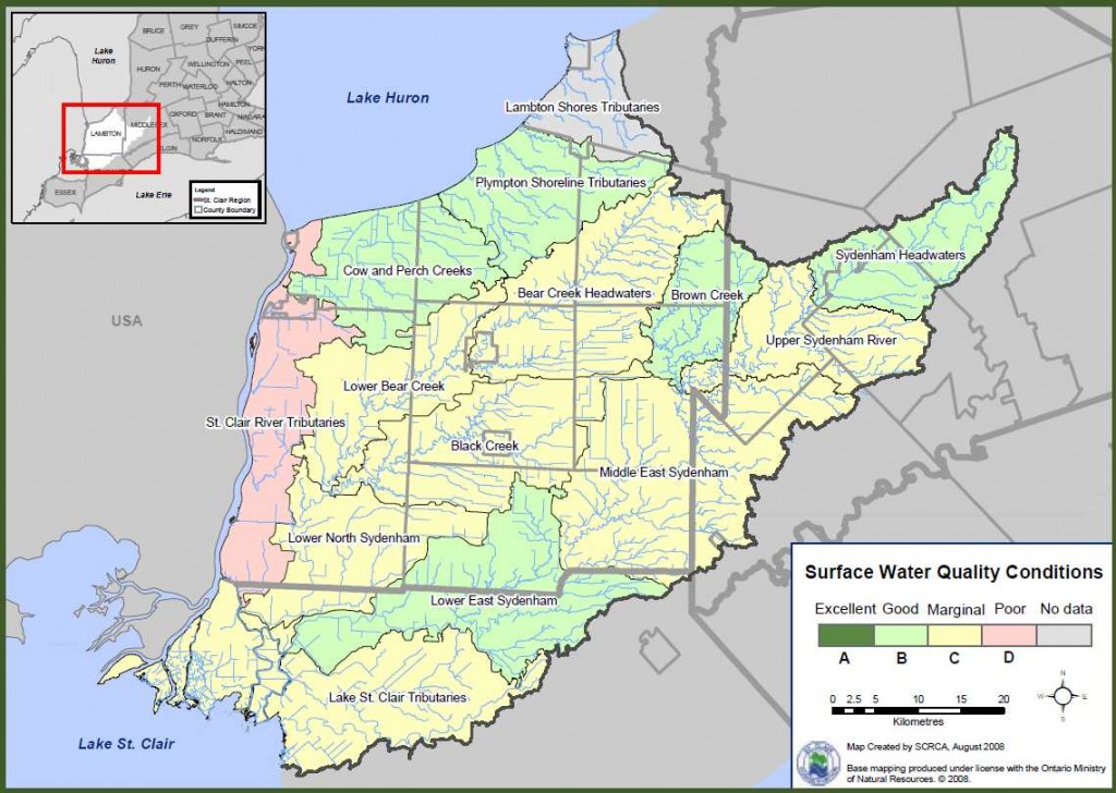
Report Card Summary Map featuring Water Quality Conditions by Subwatershed

The St. Clair Region hosts an unusual mosaic of farmland and forests, urban areas, industrialization and natural areas. This mosaic has low Report Card scores that reflect our urban, agricultural and industrial activities but the natural biological diversity is extraordinary nonetheless. Residents, agencies and municipalities must act to protect and improve this region of Canada which is “uniquely St. Clair”.

Download the 2008 Watershed Report Cards (pdf format)

  • Report Card Highlights
  • Sydenham Headwaters
  • Upper Sydenham River
  • Brown Creek
  • Middle East Sydenham River
  • Lower East Sydenham River
  • Bear Creek Headwaters
  • Lower Bear Creek
  • Black Creek
  • Lower North Sydenham River
  • Lambton Shores Tributaries
  • Plympton Shoreline Tributaries
  • Cow and Perch Creeks
  • St. Clair River Tributaries
  • Lake St. Clair Tributaries
  • Summary Report

News & Blog

  • Tyson Lozon (right) is awarded with the A.W. Campbell Memorial Scholarship by St. Clair Region Conservation Authority Chair, Greg Grimes (left).St. Clair Region Conservation Authority Celebrates 2026 Conservation Scholarship Recipients
    July 21, 2026
  • Four people standing beside the Bradshaw Conservation Lands signTTLT and SCRCF Host Recognition Event at Bradshaw Conservation Lands
    June 2, 2026
  • Scholarships Available through the St. Clair Region Conservation Authority
    May 1, 2026
  • A woman standing in a forest with blue tubing attached to treesSCRCA Hosts A.W. Campbell Maple Syrup Festival March 21 – Alvinston Firefighters Association to Hold Pancake Breakfast March 21 and 22
    March 9, 2026
  • Two men standing and shaking handsSt. Clair Region Conservation Authority Celebrates a Year of Environmental Progress at 2026 Annual General Meeting
    February 27, 2026

Upcoming Events

Ipperwash Beach Cleanup
12 Sep 26
Lambton Shores
17 Sep
SCRCA Board of Directors Meeting
17 Sep 26
Strathroy
St. Clair Conservation Foundation Memorial Forest Dedication
27 Sep 26
Petrolia
  • » View All Events
  • Regulations

    • Permits
    • Apply for a Permit
    • Drainage Act Project Review
    • Legal Inquiry

    About Us

    The St. Clair Region Conservation Authority is located in southwestern Ontario and includes the Sydenham River watershed and smaller watersheds draining directly into southern Lake Huron, the St. Clair River, and northeastern Lake St. Clair.

    The Conservation Authority implements programs to reduce the risk to life and property from flooding and erosion; water and land stewardship; forestry; wildlife habitat creation and outdoor recreation.

    Partner Links

    • Conservation Ontario
    • Thames-Sydenham & Region Source Protection Area
    • Healthy Lake Huron
    • Sydenham River Website
    • St. Clair River Sediment Management Project
    • Friends of the St. Clair River
    • Forest Gene Conservation Association
    • Lake St. Clair Canadian Watershed Management Plan
    • Ontario Trillium Foundation

    Connect with us!

    • St. Clair Region Conservation Authority
    • 205 Mill Pond Cres., Strathroy ON N7G3P9
    • 519-245-3710
    • 519-245-3348
    • stclair@scrca.on.ca

    © 2026 · St. Clair Region Conservation Authority

    • Home
    • Accessibility
    • Privacy
    • Director Access
    • Foundation Access
    • WM