-
- Upper reaches of the Sydenham River have peaked and are now falling
- Lower reaches of the Sydenham River continue to rise
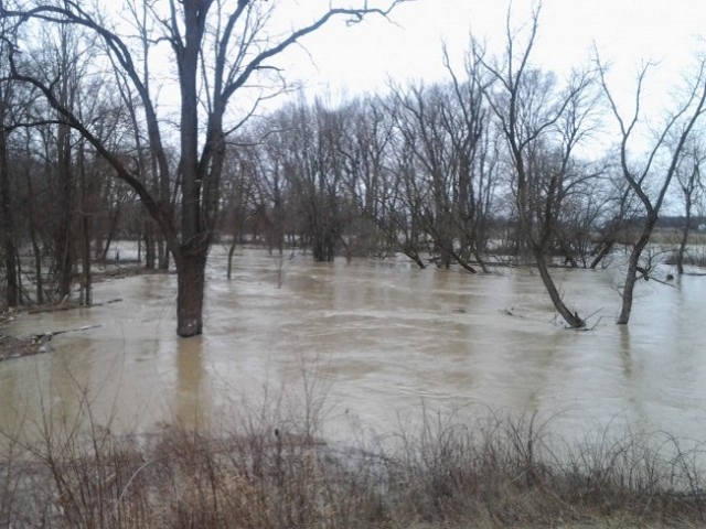
- Saturated soils, ponding, and flooding in floodplain areas
- Several roads impacted by flooding
Message: The lower reaches of Sydenham River continue to rise
Water levels across the watershed remain high and into natural floodplain areas after receiving upwards of 70 mm of rain over the past few days. The upper reaches of the Sydenham River near Strathroy and Alvinston have peaked and water levels are beginning to fall, whereas the lower reaches of the Sydenham River near Brigden, Dresden and Wallaceburg are continuing to slowly rise. Staff are closely monitoring conditions in Wallaceburg. Water levels across the region will remain high over the coming days as the water continues to make its way downstream through the watershed.
Forecasts are calling for 10-15 mm of rain beginning Monday afternoon, with additional precipitation continuing into Tuesday and Wednesday. Staff will continue to monitor the changing weather forecasts as the system evolves. Moderate amounts of additional rain to the system will slow the fall in water levels.
-
- Stanley Line between Kimball and Wabuno Road
- Pretty Road north of McCallum Line
- Waterworks Road north of Courtright Line
- Telfer Road between Courtright Line and Moore Line
Individuals are reminded to avoid watercourses and flooded areas due to dangerous conditions, slippery banks and cold, swift moving water. Children and pets should be kept away from the water.
The Conservation Authority continues to monitor watershed conditions and will issue advisories to municipalities and media should flood issues arise.
Municipal emergency response staff and road superintendents should monitor local conditions closely.
This message will remain in effect until Tuesday, April 4, 2023 at 12pm unless otherwise updated.